



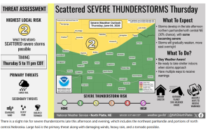
Nebraskans may experience multiple rounds of strong to severe thunderstorms over the next two days as weather conditions become increasingly favorable for storm development.
The National Weather Service in North Platte has placed portions of northern Nebraska under a Slight Risk, or Level 2 out of 5, for severe weather on Thursday afternoon and evening. The greatest concern extends across parts of the northeast Panhandle and north-central Nebraska, including areas near Valentine, Ainsworth, Mullen, and Thedford.
Forecasters say storms could begin developing late Thursday afternoon and continue through the evening hours. Large hail is expected to be the primary threat, although damaging winds, heavy rainfall, and an isolated tornado cannot be ruled out. Any storms that develop are expected to move east and gradually weaken overnight.
The severe weather threat is expected to shift and expand on Friday.
The Storm Prediction Center has also placed much of central and eastern Nebraska under a Slight Risk for severe thunderstorms on Friday, June 5. High temperatures climbing into the 80s and lower 90s, combined with a developing area of low pressure across the region, are expected to create an increasingly unstable atmosphere.
According to the National Weather Service in Hastings, a warm front, a cold front, and a surface low will set up across Nebraska during the day. The exact placement of those features will determine where the strongest storms develop, but forecasters say conditions appear favorable for thunderstorms to rapidly intensify by late afternoon and evening.
Meteorologists expect a cap that has limited storm development during the day to weaken later Friday, potentially allowing storms to develop quickly. Large hail, damaging winds, heavy rainfall, and a few tornadoes will all be possible with the strongest storms.
Storms are expected to push east Friday night as a cold front moves through the state. Additional chances for showers and thunderstorms remain in the forecast through the weekend and into early next week.
Residents are encouraged to stay alert to changing weather conditions and have multiple ways to receive watches and warnings, especially if they have outdoor plans on Thursday or Friday evening.