


NORTH PLATTE — Severe thunderstorms are expected to develop across parts of western and central Nebraska later today, with large hail, damaging winds, and a few tornadoes all possible.
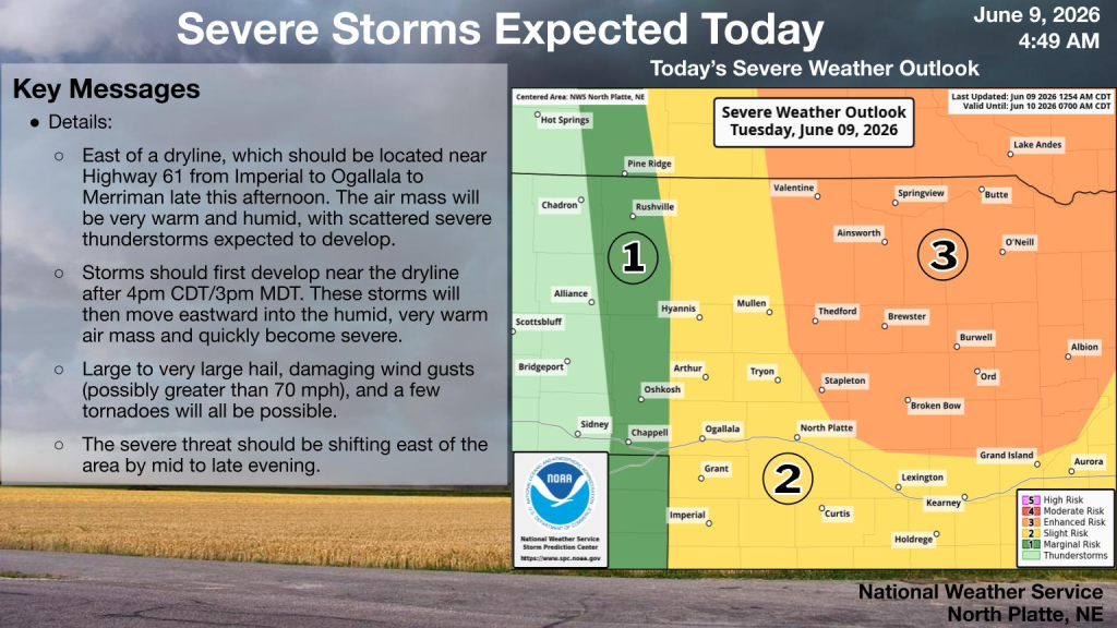
According to the National Weather Service in North Platte, storms are expected to form east of a dryline that should be located near Highway 61, stretching from Imperial to Ogallala and north toward Merriman late this afternoon.
Forecasters say the air mass ahead of the dryline will be very warm and humid, helping scattered severe thunderstorms develop. Storms are expected to first form near the dryline after 4 p.m. Central Time, or 3 p.m. Mountain Time, before moving east into the more humid air and quickly becoming severe.
The greatest risk area includes much of north-central Nebraska, including communities such as Valentine, Ainsworth, Thedford, Brewster, Burwell, Ord, and Broken Bow. That area is under an enhanced risk for severe weather. Areas farther south and west, including North Platte, Lexington, Kearney, Ogallala, and Imperial, are under a slight risk.
Main hazards include large to very large hail, damaging wind gusts possibly greater than 70 miles per hour, and a few tornadoes. The severe weather threat is expected to shift east of the area by mid to late evening.
Residents are encouraged to stay weather aware, have multiple ways to receive warnings, and be ready to move indoors quickly if severe weather develops.