



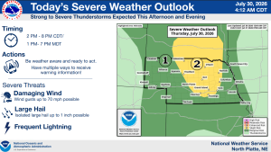
NORTH PLATTE, Neb. — Strong to severe thunderstorms are expected to develop Thursday afternoon across portions of western and north-central Nebraska, with damaging winds considered the primary threat.
The National Weather Service in North Platte said storms will be most likely between 2 and 8 p.m. CDT, or 1 and 7 p.m. MDT. Wind gusts could reach 70 mph, while isolated hail up to one inch in diameter and frequent lightning are also possible.
An isolated tornado cannot be ruled out, although the greatest concern remains damaging straight-line winds.
The Storm Prediction Center has placed much of central and north-central Nebraska under a slight risk for severe weather. The area includes communities near Broken Bow, North Platte, Thedford, Valentine, Ord, and O’Neill. Portions of western Nebraska are under a marginal risk.
The outlook covers Custer, Lincoln, Frontier, Blaine, Loup, Logan, Garfield, Wheeler, Thomas, Hooker, Keith, Perkins, Chase, Hayes and several surrounding counties.
Residents with outdoor plans are encouraged to remain weather-aware and have multiple ways to receive warnings. Spotter activation is not expected at this time.
The National Weather Service said the chance for widespread hazardous weather is low from Friday through Wednesday.